


Map of Hertfordshire countryside under threat
Welcome to CPRE Hertfordshire’s new digital map showing development proposals that threaten the Hertfordshire countryside and Green Belt.
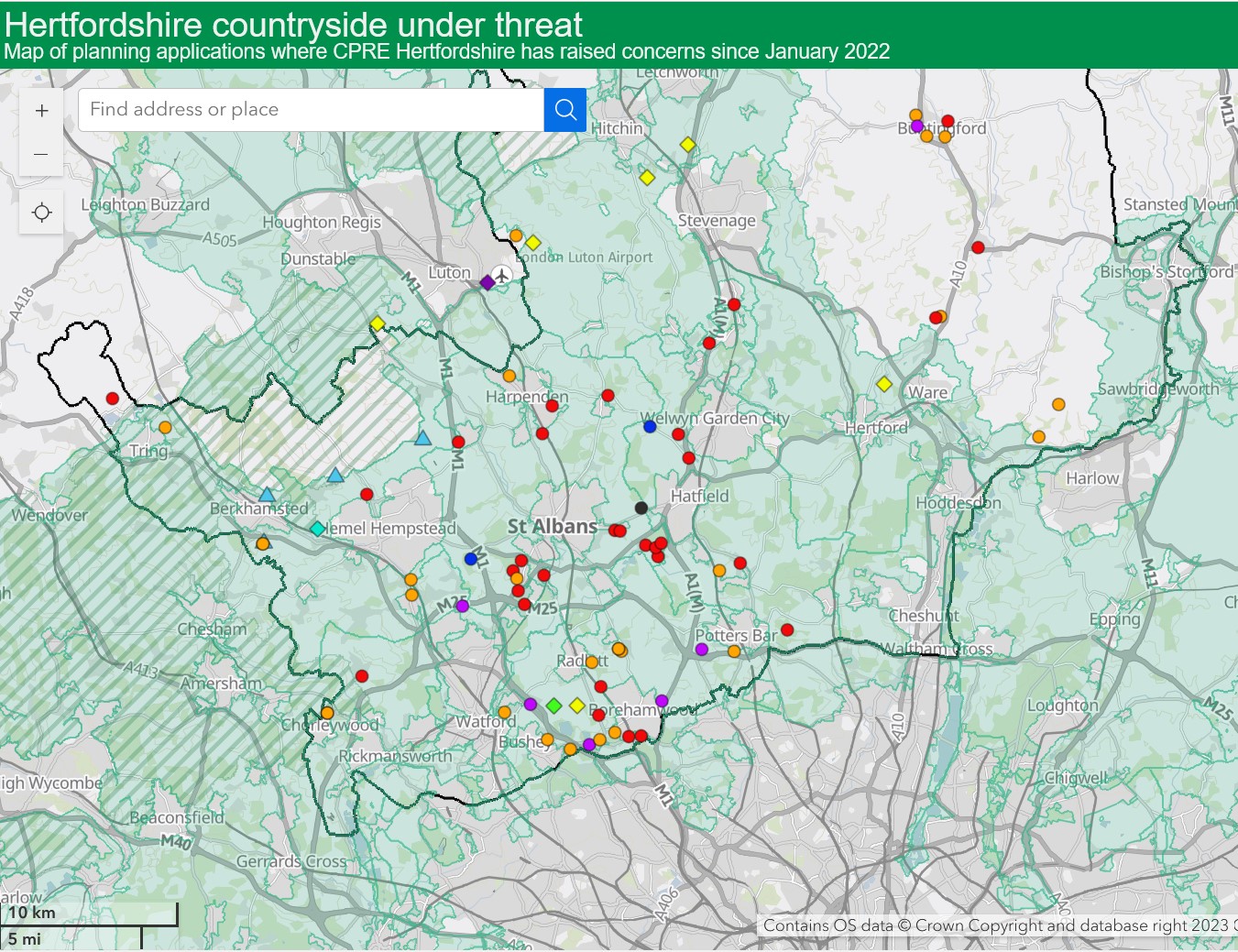
Our digital map currently shows planning applications where CPRE Hertfordshire has raised concerns since January 2022. Local Plan proposed site allocations are not shown but will be added at a later date.
It’s easy to use – just click on the site marker and the pop-up box will give you details of the proposed development. To find out more, click on the link to the CPRE Hertfordshire website where you will find our response letters or follow the link to the local authority website for full details and plans.
Our digital map includes planning applications for the following types of development in the countryside: residential (20+ new dwellings), commercial / employment uses, large scale ground-mounted solar installations, battery energy storage systems (BESS), suitable alternative natural greenspaces (SANG), airport expansion, mineral extraction, and sport. And by adjusting the layers, you can clearly see if a particular area is within the Green Belt, and/or the Chilterns National Landscape (formerly known as Area of Outstanding Natural Beauty or AONB).
If you have any questions or feedback, please email us at: planning@cpreherts.org.uk
Click on this button to view the map.
Please note:
- This is not a definitive map and should not be relied on for any legal or property related purposes.
- The data relates to applications submitted to Hertfordshire planning authorities since January 2022.
- Site markers show approximate locations – refer to Local Authority website for location maps.
- We do our best to keep the data current but the status of planning applications changes frequently – refer to Local Authority website for current status on decisions and appeals.
- Some applications may no longer be live but are kept on the map for monitoring purposes.
- The map only shows applications and proposals where CPRE Hertfordshire has raised concerns. It is not a comprehensive record of all applications in the Hertfordshire countryside. Residential sites of less than 20 dwellings are not included.
- The absence of a site marker does not necessarily mean there is no planning history or threat in this location. Always check the Local Authority website and current and emerging Local Plans.
- This ArcGIS Online map is hosted by Esri. Map image is the intellectual property of Esri and is used herein under license. Copyright © 2020 Esri and its licensors. All rights reserved.
- English local authority Green Belt dataset published by Ministry of Housing, Communities and Local Government December 2023. Areas of Outstanding Natural Beauty (England) (now known as National Landscapes) dataset published by Natural England. Revision date June 2024.
Authored by CPRE Hertfordshire. This map must not be copied or used by any third party without obtaining permission from CPRE Hertfordshire.
– – –
This map has been created with help from a member of our amazing volunteer team. If you are interested in becoming a CPRE volunteer, find out more here.
CPRE Hertfordshire is not a statutory consultee for notification of planning applications so we rely on a team of volunteers to keep a watch on new planning applications that might threaten the countryside. Between them, they screen over 15,000 planning applications across Hertfordshire every year and, after a thorough assessment process, we submit comments and raise the alarm on a very small proportion of these, usually around 70 – 80 each year.
